Nestled within the boundaries of Meixian County in Shaanxi Province, Mount Taibai National Forest Park (太白山国家森林公园, Taibai Mountain) is a majestic treasure located at the northern foothills of the Qinling Mountains, home to the primary peak of the range, Mount Taibai. Rising to an impressive elevation of approximately 3,767 meters, Mount Taibai exhibits a stunning and imposing presence. The park boasts breathtaking natural scenery, with its summit often covered in snow even during the peak of summer. Looking out from the Guanzhong Plain, the snow-covered summit creates an enchanting and picturesque vista.
The park predominantly features lush forests, adorned with rugged mountain peaks, clear streams, and historical sites. The towering peaks of the park reach up into the clouds, making it a renowned tourist destination in Shaanxi. Due to its complex terrain, the park is particularly suitable for nature enthusiasts and outdoor hiking enthusiasts who seek an authentic and unspoiled experience. Mount Taibai offers numerous routes for climbers, with paths ascending from both the north and south sides of the mountain, including cable car and hiking options.
Table of Contents
- Basic Information
- Location and Transportation
- Highlights of Mount Taibai
- Map and Recommended Routes
- Vlog about Mount Taibai
- Geological Features of Mount Taibai
- Climate at Mount Taibai
- Useful Tips Summarized from Reviews
- Other Mountains near Xi’an
Basic Information
| Website | http://www.tbpark.com/ |
| Estimated Length of Tour | About 1 day |
| Ticket Price | 90 RMB (1st March – 30th November) 54 RMB (1st December – 28th February the next year) |
| Shuttle Bus Ticket | 120 RMB for round trip |
| Opening Hours | 08.00 – 16.00; Last admission: 15.00 |
Location and Transportation
Mount Taibai is situated in the southern part of the Qinling Mountains, in the northern part of Shaanxi Province. Specifically, it lies in Mei County, Baoji City, about 80 kilometers (50 miles) away from Xi’an, the capital city of Shaanxi.
To get to Mount Taibai from Xi’an, you can take the express coach at Xi’an Bus Station, opposite Xi’an Railway Station. It takes about 2 hours and costs 37.5 RMB.
Highlights of Mount Taibai
Sea of Clouds
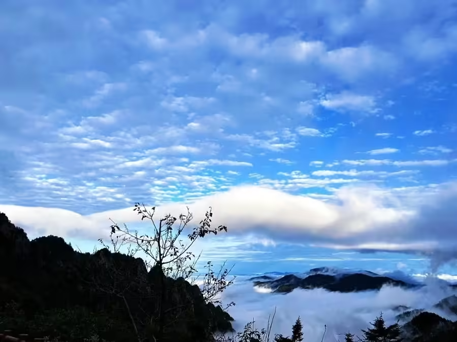
Mount Taibai offers spectacular views of the sea of clouds, especially above 2000 meters in altitude. The most renowned viewpoint is at Ping’an Temple, situated at 2700 meters on a ridge. Surrounded by towering peaks and deep ravines, Ping’an Temple provides a panoramic vista of the cloud formations. To the south, peaks like Baxiantai, Paoma Ridge, and Aoshi Mountain resemble camel humps, while to the northwest, the winding Taochuan River can be faintly seen. Standing at Ping’an Temple, visitors witness a dramatic display of cloud patterns: sometimes tumultuous and relentless, other times calm and serene with mist lifting, or enveloped in thick, pervasive clouds. During sunny mornings and evenings, the cloud sea is bathed in golden hues, transforming the landscape into a mythical realm.
High Mountain Glacial Lakes
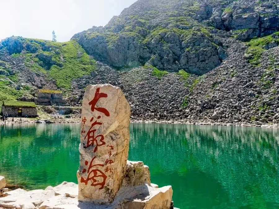
South and north of Baxiantai lie several glacial lakes formed by ancient ice activity. The largest is Yuhuang Pool, located on the southern slope of Baxiantai at 3380 meters. Covering about 30 acres, this round lake resembles a full moon and, on clear days, reflects the shimmering blue sky, white clouds, and surrounding peaks, creating a mesmerizing scene. Nearby are the smaller Fo Pool and Sanqing Pool.
San Taibai Sea is situated in a trough north of Yuhuang Pool, shaped like a jade ruyi (a ceremonial scepter). Er Taibai Sea lies above San Taibai Sea, resembling an imperial scepter. The largest, Da Taibai Sea, is in a trough north of Baxiantai, circular in shape with a surface area of 13.8 acres. On clear days, the lake’s crystal-clear waters and cool, refreshing temperatures captivate visitors. During rainy seasons, the lake often overflows, and the rushing water echoes through the valley, creating a dramatic and audible spectacle. The weather in this area is highly variable; the lake surface can suddenly be shrouded in mist, rendering nearby features invisible, or become clear with the landscape in full view. Locals refer to this mist as “divine tents.”
Temple Complex

Mount Taibai boasts an exceptional collection of ancient temples and structures, a rarity in the history of Chinese architecture. These include the Sha Po Temple, Jiaolong Temple, Heihu Pass, Songping Temple, Zhongshan Temple, the Grand Hall, Doumu Palace, Ping’an Temple, Mingxin Temple, Fangyang Temple, Wengong Temple, Sanguan Temple, Yaowang Palace, Lianhua Temple, and Taibai Temple, among others. Many of these temples and structures are built with iron tiles, and the statues of deities are often made of iron or wood carvings. The harsh climate at the mountain’s summit, with its icy peaks and snowy terrain that persists throughout the year, creates a mesmerizing and spectacular landscape that stretches for miles, offering a truly unforgettable experience.
Ba Xian Terrace

The Ba Xian Terrace is the highest point on Mount Taibai. Looking up from below, the temple on the peak appears to float in the sky, perched on the edge of a sheer precipice. However, upon reaching the summit, a spacious and level platform is revealed. From this vantage point, visitors can enjoy breathtaking panoramic views of the surrounding landscape. On clear summer days, the view to the north offers a sight of the Guanzhong Plain, with the Wei River winding like a ribbon through the landscape, creating a mesmerizing pattern of fields and roads. Villages, towns, and factories can be seen in the distance. During sunset or sunrise, the mountain is bathed in hues of red and gold, casting a surreal and awe-inspiring glow across the rock walls and cliffs.
Outdoor Activities

Mount Taibai offers visitors a wide range of outdoor activities to enjoy, making it a popular destination for nature lovers and adventure enthusiasts. Some of the most popular outdoor activities in Mount Taibai include hiking, trekking, and camping (Taibai Mountain Traverse). The mountain has numerous trails that offer varying levels of difficulty, allowing visitors of all fitness levels to enjoy the scenery. In addition to hiking, visitors can also enjoy birdwatching, fishing, and skiing during the winter months. For those who prefer a more leisurely experience, the cable car ride to the summit of the mountain offers panoramic views of the area.
Map and Recommended Routes
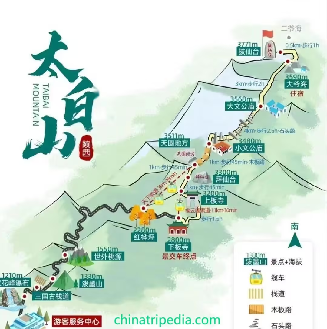
Route A starts at the Visitor Center, where you take a shuttle bus to Red Birch Plain. From there, you ride the Tianxia Cable Car to the summit, Tianyuan and Difang, where you can enjoy the panoramic views of the “boundary of the divine land of China, the watershed of Huaxia.” You then return via the same route.
This route is suitable for visitors with lower fitness levels and typically takes around 4-5 hours for a round trip.
Route B also begins at the Visitor Center with a shuttle bus ride to Red Birch Plain. You then take the Tianxia Cable Car to the summit, Tianyuan and Difang. The route then continues downhill through Xiaotian Dog Peak, the Glass Viewing Platform, and Baixiantai. From there, you visit Ban Temple New Village and ascend to Ban Temple. The route concludes with a ride down via the Fuyun Pavilion Cable Car to Xiaoban Temple, followed by a shuttle bus back to the Visitor Center.
This route is ideal for more physically active visitors and takes about 5-6 hours, featuring original forest landscapes along the way.
Route C begins at the Visitor Center with a shuttle bus to Red Birch Plain. From there, you hike through Xiaoban Temple and Ban Temple, visit Baixiantai, and then reach the summit, Tianyuan and Difang. You return by taking the Tianxia Cable Car back down.
This route is suitable for experienced hikers and the hike from Red Birch Plain to Tianyuan and Difang usually takes around 3 hours, with the total round trip taking approximately 5-6 hours.
Vlog about Mount Taibai
Geological Features of Mount Taibai
Mount Taibai, located in the Qinling Mountains of China, exhibits a diverse range of geological features that can be categorized into three distinct geomorphological zones: the Low Mountain Area, the Middle Mountain Area, and the High Mountain Area. Each zone is characterized by unique formations and landscapes, shaped by varying processes over time.
Low Mountain Area
Situated at elevations between 800 and 1300 meters, the Low Mountain Area of Mount Taibai is characterized by a combination of loess-covered and rocky terrain. This region features relatively gentle topography with rounded mountain peaks due to the thick layer of loess, a type of wind-deposited silt. In areas where the loess is eroded away, the underlying bedrock is exposed. Water flow frequently follows fault lines, leading to the formation of deep, narrow valleys and ravines. The terrain in this zone is marked by its gradual undulations and more subdued elevation changes.
Middle Mountain Area
Ranging from 1300 to 3000 meters in elevation, the Middle Mountain Area is distinguished by its rugged, rocky landscape. The northern slopes extend from Liujiaya to Fangyangsi, while the southern slopes stretch from Huangbaiyuan to Sanqingchi. This region is notable for its deeply cut valleys with V-shaped cross-sections, steep ridges, and serrated peaks. The area below the Great Hall features deep, narrow gorges, while above this level, the landscape becomes increasingly dramatic with dense forested areas, towering rock formations, and intricate rock outcrops. The rock formations here are highly varied, with towering granite pillars near Doumu Palace and unique formations like the “grain stack” rocks on the northeast ridge of the Great Hall. The area between Doumu Palace and Fangyangsi is characterized by large, blocky rock masses that create a labyrinthine appearance in the valleys.
High Mountain Area
Above 3000 meters, the High Mountain Area extends to the summit of Mount Taibai and is distinguished by well-preserved Quaternary glacial landforms. This region clearly displays the effects of past glacial activity. The glacial landforms here include both ice-eroded and glacial moraine features. Ice-eroded landforms are evident in the form of cirques, angular peaks, and U-shaped valleys, while the glacial moraine features primarily consist of terminal moraines. The central area of glacial activity is around Baxiantai, where various glacial features are concentrated. The surrounding landscape exhibits the remnants of ancient glaciers, with prominent features such as cirques and sharp ridges that highlight the powerful sculpting effects of past glaciation.
Climate at Mount Taibai
Useful Tips Summarized from Reviews
Bring Your Own Food: While there are food vendors on the mountain, prices are significantly higher than in the city, approximately four to five times more expensive. It’s advisable to bring your own food to save money and ensure you have snacks or a meal readily available.
Portable Oxygen Tanks: Oxygen canisters are available for purchase, with prices varying depending on the location. Be prepared to spend around 50 to 90 yuan for a portable oxygen tank. These can be useful, especially if you experience altitude sickness or difficulty breathing due to the thin air at higher elevations.
Wear Suitable Footwear: Proper footwear is essential for hiking Mount Taibai. The terrain is rugged and rocky, and inappropriate shoes can lead to discomfort, blisters, or even injuries. Ensure you wear sturdy hiking shoes or boots to prevent foot problems during your hike.
Be Cautious on Trails: The trails in the natural reserve area can be challenging, with narrow paths and steep cliffsides. If you’re afraid of heights or not accustomed to strenuous hiking, proceed with caution. Some sections may require you to use your hands and feet for stability, making it physically demanding. Take breaks when needed and assess your energy levels before continuing.
Consider Overnight Stay at Da Ye Hai: If you plan to hike to Da Ye Hai (Big Grandpa Lake) and find the journey exhausting, consider staying overnight at the campsite there. Accommodations include bunk beds, and there are shops and Wi-Fi available for a fee. It’s wise to carry cash as there may be no cellular signal on the mountain.

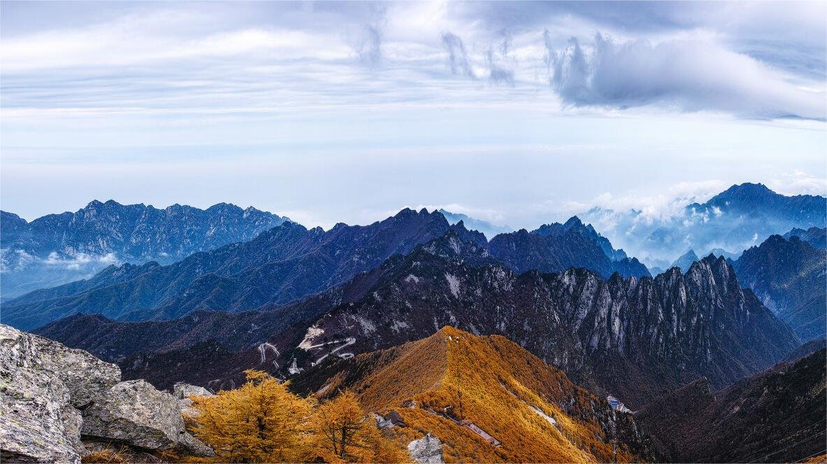



Currently, you can only climb up to the 【天圆地方】(Tian Yuan Di Fang). The next few places are closed off due to freezing, so you can’t continue. If you are just visiting for the attractions further ahead, you don’t need to spend money to come here, as it’s quite expensive. Although it’s closed off, I saw online that some visitors took a wild route and climbed up from the back mountain. If you lack experience, it’s best not to mess around!