Binhai Road in Dalian (大连滨海路) is a scenic coastal highway stretching over 30 kilometers, offering breathtaking views of the sea. Originally built in the 1970s as a military road guarded at both ends, Binhai Road was opened to the public in the early 1980s after Deng Xiaoping’s visit to Dalian, transforming it into a popular tourist route. With numerous well-known attractions along the way, it has become a favorite spot for walking and photography. The road connects the mountains and the sea, symbolizing enduring love and earning the nickname “Lover’s Road.”
The northern section of Binhai Road features the picturesque Haizhiyun Park, while the eastern section is home to popular summer destinations like Bangchuidao Island, Shicao Scenic Area, and Laohutan Ocean Park. The central section includes attractions such as Beida Bridge, Yanwoling, Xiu Yue Peak, and Fujiazhuang Park. When combined with the western section’s Forest Zoo and Xinghai Square, Binhai Road forms a stunning route perfect for hiking and photography. Walking the entire route takes approximately 3 to 4 hours.
Table of Contents
- Basic Information
- Location and Transportation
- Highlights of Binhai Road
- Vlog about Binhai Road
- Attractions near Binhai Road
Basic Information
| Estimated Length of Tour | Half a day |
| Ticket Price | Free |
| Opening Hours | 24 hours a day throughout the year |
| Telephone Number | 0086-0411-62917750 |
Location and Transportation
Binhai Road is located in Dalian, Liaoning Province, China. It stretches from Haizhiyun Square in the east to Xinghai Square in the west. The section from Haizhiyun Square through Bangchuidao Island to the Laohutan Scenic Area is commonly referred to as the eastern or northern segment. Meanwhile, the portion from Laohutan through Fujiazhuang and the Forest Zoo to Xinghai Square is known as the western or southern segment. To get there, you can choose one oft he folloing ways:
Xinghai Square (Western Segment):
- Take bus route 49 to Yifang Castle (Bus Stop), then walk to the square.
- Alternatively, take Metro Line 1 to Xinghai Square (Metro Station), and exit from A1/A2, followed by a short walk.
Laohutan and Fujiazhuang (Central Segment):
- Take bus routes 2, 403, 404, 47, or 4 to Jiefang Road (Bus Stop), then walk to the destinations.
- For Fujiazhuang, take bus routes 47, 501, 541, or 5 to Fujiazhuang (Bus Stop) and walk.
During the peak tourist season, you can also take a city sightseeing bus to Binhai Road.
Highlights of Binhai Road
Beida Bridge
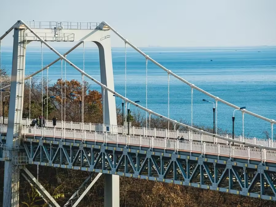
Beida Bridge (北大桥) in Dalian was constructed as a symbol of friendship between Dalian and Kitakyushu, Japan, after the two cities became sister cities. In Kitakyushu, a Chinese-style pavilion named “Dabei Pavilion” was built, while in Dalian, Beida Bridge was constructed to commemorate the enduring friendship between the people of the two cities. The bridge is located between the Laohutan Scenic Area and Yanwoling Scenic Area within Dalian’s coastal scenic zone. It is a land bridge spanning a valley near the sea, strategically positioned along Binhai Road, which runs through the entire coastal scenic area of Dalian. The bridge is 230 meters long, with a central span of 132 meters and a width of 12 meters.
Yanwoling Ridge

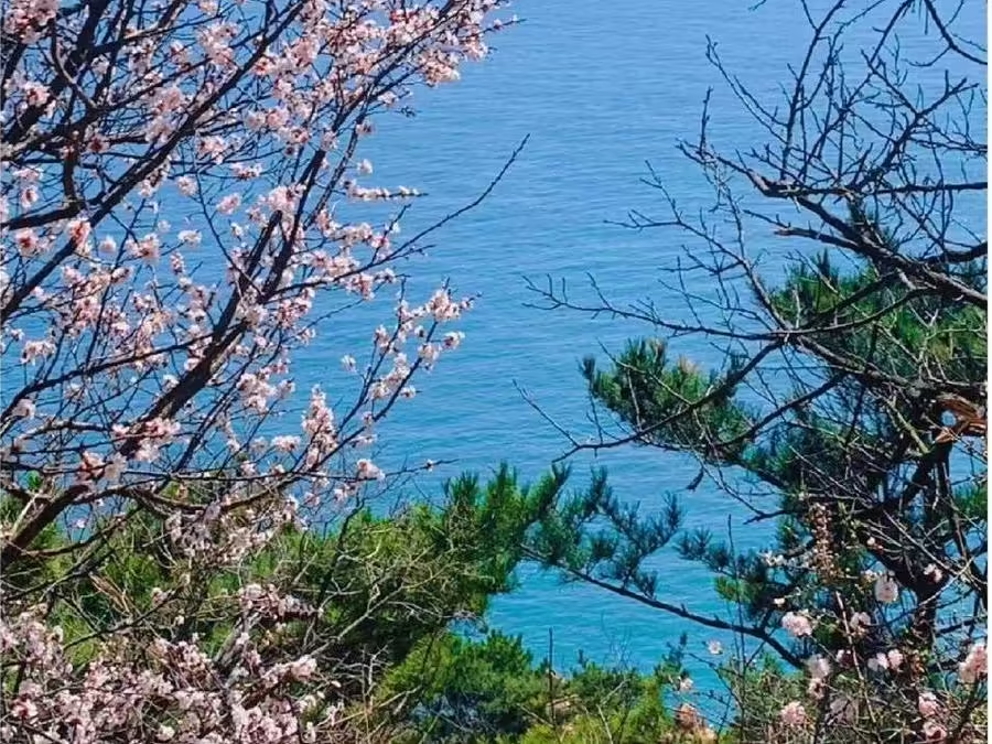
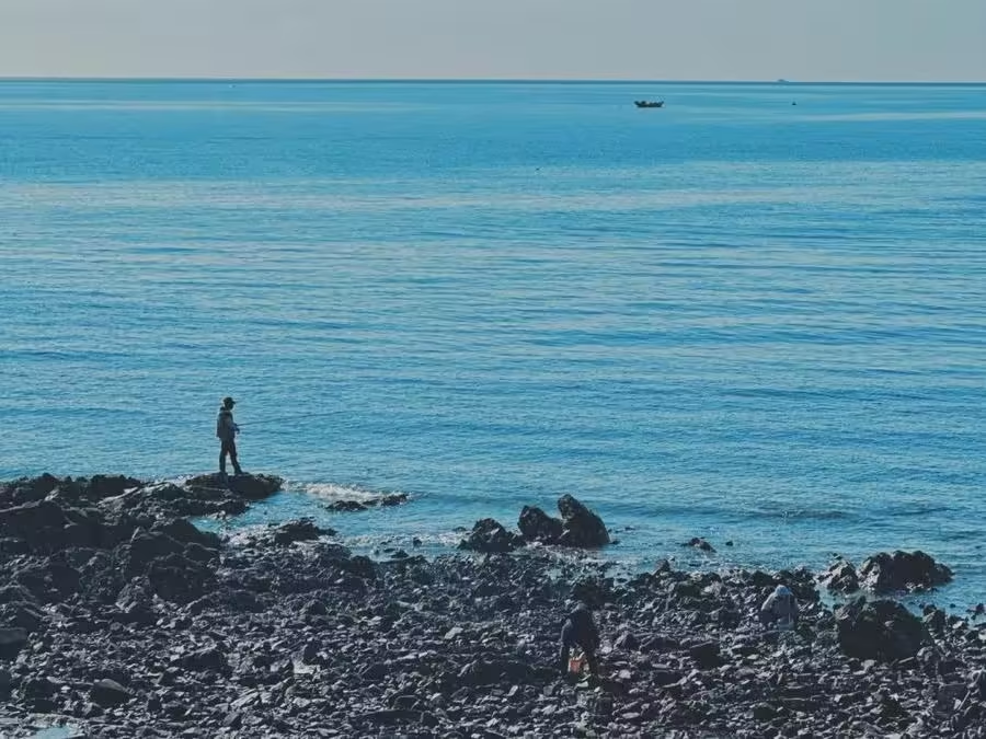
Yanwoling Ridge (燕窝岭), situated in the eastern section of Binhai Road’s central segment, covers an area of 0.8 square kilometers. The mountain range in the area runs east-west, forming a ridge approximately 1 kilometer long. It is named “Yanwoling” because of the frequent sightings of black swallows in the area. The ridge runs parallel to the coastline, with the southern side facing the sea, where sheer cliffs drop several dozen meters into the water below. Yanwoling is one of the most distinct coastal scenic areas in the southern seaside region, known for its dramatic coastal landscapes. After renovations, the area has been transformed into a themed park for wedding ceremonies. The coastal features are well-developed, offering unique and picturesque scenery, with quiet valleys, slopes covered in wildflowers, and native grasses. The rocky shores of Yanwoling, rich in marine life, also make it an ideal spot for fishing.
Xiu Yue Peak Scenic Area
Xiu Yue Peak Scenic Area (秀月峰景区) is located at the eastern end of the central section of Dalian’s coastal scenic zone, to the west of Laohutan Scenic Area and adjacent to Yanwoling Scenic Area to the south. The area covers 5.19 square kilometers and is situated 6 kilometers from the city center. The landscape is dominated by hilly terrain with nine peaks, the highest being Xiu Yue Peak, which stands at an elevation of 214.3 meters. From the summit of Xiu Yue Peak, visitors can enjoy panoramic views of the sea and the surrounding urban landscape.
Fujiazhuang Scenic Area
Passing through Xiu Yue Peak Scenic Area leads to Fujiazhuang Scenic Area (傅家庄景区), one of Dalian’s top ten scenic spots. This area is distinguished by its unique natural landscape, featuring high plateau terrain to the east and west, with a broad beach in the center. The eastern and western Dalian Islands are visible across the sea, creating a multi-dimensional space that includes the sea, mountains, reefs, and beaches. The geographic conditions are highly favorable, with picturesque natural scenery and several excellent natural seawater bathing beaches.
The western part of the scenic area is home to Fujiazhuang Park, which features a 550-meter-long beach, one of Dalian’s four major bathing beaches. The eastern part of the area has been developed into a resort and tourist service center, with various distinctive architectural groups scattered among the surrounding mountains.
Baiyun Mountain Scenic Area

Baiyun Mountain Scenic Area (白云山景区) is the largest scenic area within Dalian’s coastal scenic zone, covering nearly 7.5 million square meters. It is home to the largest forest zoo in northern China. This area is also the closest scenic spot to Dalian’s city center, with the western Dama Mountain of Binhai Road located just 2 kilometers away. The northwestern part of the area features a significant geological formation known as the “Lotus-Shaped Structure,” discovered by renowned Chinese geologist Li Siguang. The area boasts ten newly developed scenic spots, including the Forest Zoo, Wonders of Nature, Baiyun Swans, Baiyun Villa, Xishan Scenic Overlook, World Gardens, Masterpieces of Sculpture, Cloud Wanderer, Tiger Tracking, and Mingshan Buddhist Monastery.
Shibapan

Shibapan (十八盘) is one of the steepest sections of Binhai Road, beginning where the road veers away from the sea and climbs directly up to the mountain peak. It is located between Bangchuidao Island and Siergou. At the top of Shibapan, there is a peculiar slope about 60 meters long and 4 meters wide, known as the “Mystery Slope.” This slope, which is higher in the south and lower in the north, takes on a reverse “Z” shape. A curious phenomenon occurs here: when a car reaches the bottom of the slope, it can ascend to the top without any engine power; similarly, a cyclist can reach the top without pedaling. Conversely, going downhill requires extra effort.