Changbai Mountains (长白山, Forever-White Mountain), located in the southeastern part of Jilin Province, are the highest mountain range along the eastern edge of the Eurasian continent, sitting at the border between China and North Korea. The mountains are named after their main peak, which is often covered in white pumice and snow. The highest peak within China, Baiyun Peak, stands at 2,691 meters, making it the tallest peak in Northeast China, while the highest overall peak, Janggun Peak, is in North Korea. Changbai Mountains are also home to China’s largest and highest volcanic structure.
The name “Changbai” carries a symbolic meaning of “lasting companionship until old age.” The scenic area spans 52.42 square kilometers and is divided into three main areas: the western, northern, and southern slopes. Key attractions include the sixteen peaks of Changbai, the alpine garden, and the unique volcanic and vertical vegetation landscapes. Notable features such as Tianchi (Heavenly Lake), waterfalls, snow sculptures, and dense forests have earned the mountains numerous Guinness World Records and the titles of one of China’s ten most famous mountains, one of the most beautiful lakes, and one of the ten most beautiful forests in China.
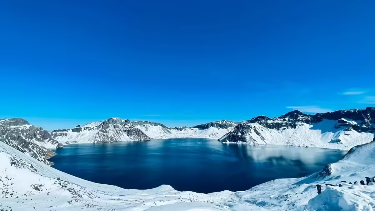
Changbai Mountains are a dormant volcano, with the breathtaking and sacred Tianchi lake sitting in the crater of the main peak, considered a must-see for visitors. It is also seen as a place of spiritual significance. Visitors can reach the summit to view Tianchi from the north, west, or south slopes. While the north slope is rockier with limited views, the west and south slopes offer broader vistas. The best time to catch a glimpse of Tianchi is from July to September, though the weather at the summit can change rapidly.
Table of Contents
- Basic Information
- Location and Transportation
- Highlights of Changbai Mountain West Slope
- Highlights of Changbai Mountain North Slope
- Highlights of Changbai Mountain South Slope
- Map and Recommended Itinerary
- Geology and Climate of Changbai Mountain
- History of Changbai Mountain
- Vlog about Changbai Mountain
- Other Attractions in Yanji City
Basic Information
| Estimated Length of Tour | 1 – 3 days |
| Ticket Price | North Slope: 235 RMB (admission + bus) West Slope: 214 RMB (admission + bus) South Slope: 190 RMB (admission + bus) |
| Opening Hours | North Slope: 7.30 – 17.00 (1st September – 30th April) 7.00 – 17.00 (1st May – 31st August) Last admission: 14.30 West Slope: 8.00 – 15.30 (1st September – 30th April) 7.00 – 15.30 (1st May – 31st August) Last admission: 12.30 South Slope: 8.00 – 13.00 (only open during summer) |
| Telephone Number | 0086-0433-5742286 0086-0439-6331900 |
Location and Transportation
Changbai Mountain is located in the southeastern part of Jilin Province, within the Yanbian Korean Autonomous Prefecture, specifically in Erdao Baihe Town, Chibei District, Antu County. The geographical coordinates are approximately 41°41’49” to 42°51’18” North latitude and 127°42’55” to 128°16’48” East longitude. The mountain is bordered by North Korea to the southeast, making it a unique geographical area.
By Air:
- Changbai Mountain Airport: Located in Songjianghe, this airport is only about 15 km from the West Scenic Area.
- Changchun Longjia Airport: You can take an airport shuttle or high-speed train to Changchun Railway Station, then transfer to a high-speed train heading to Changbai Mountain Station. After arriving, take a bus to the North Scenic Area Tourist Distribution Center.
- Yanji Chaoyangchuan Airport: From here, you can take a bus to Yanji West Station and then transfer to a high-speed train to Changbai Mountain Station. Alternatively, you can hire a car or share a ride to Erdao Baihe Town or Songjianghe Town.
By High-Speed Train:
- Changbai Mountain Station (Erdao Baihe Town): After arriving at the station, take Bus Line 1 to the North Scenic Area Tourist Distribution Center. If driving, navigate directly to the North Scenic Area Tourist Distribution Center; do not drive to the scenic area gate as tickets are checked before entering.
By Train:
- North Slope Train Station: The North Slope Train Station is adjacent to the high-speed train station. You can buy a ticket directly to Changbai Mountain Station, which is within walking distance of Erdao Baihe Town and various attractions.
- West Slope Train Station: This station is at Songjianghe, but it requires climbing stairs to access. It’s not recommended for those who dislike physical exertion. If you’re fit, consider taking a night train to explore the North Slope the next day.
- South Slope: Located in Manjiang Town near the China-North Korea border, there are no direct train services. It’s best to consult with your hotel for carpooling options (note that this area is usually closed in Winter).
Highlights of Changbai Mountain West Slope
Alpine Garden

The Alpine Garden is one of the most famous attractions in the western scenic area of Changbai Mountains in Yanbian Korean Autonomous Prefecture. Situated at an altitude of about 1,400 meters, it experiences a temperate mountain climate. The garden features a vast area of flowers that flourish on slopes, under forests, in valleys, and by rivers. Among the most famous flowers here are irises, lilies, daylilies, trollflowers, meadowsweet, and hellebores. Every spring and summer, various wildflowers bloom, creating a “vast flower garden” across thousands of acres. In July, flowers such as lilies, daylilies, irises, and fringed pinks bloom in abundance.
Panting Slope

Panting Slope is known for its steep incline, with an angle of over 70 degrees. A narrow path leads directly to the top, requiring visitors to continuously climb. Due to its elevation ranging from 1,800 to 2,000 meters, the air becomes thin, causing climbers to breathe heavily—hence the name “Panting Slope.” Interestingly, although this altitude should typically be home to birch trees, spruces, firs, and larches also thrive here. This is because the slope faces the sun and receives abundant sunlight, creating a mild microclimate.
Golden Thread Spring and Jade Pulp Spring

Golden Thread Spring is located on the eastern slope of Yuzhu Peak, near the western shore of Tianchi (Heaven Lake). The water flows between two stone pillars, shimmering like golden threads in the sunlight. According to legend, the spring is home to a rain officer of Changbai Mountains—a winged double snake. When the snake takes flight, heavy rain falls on the mountains.
Jade Pulp Spring is also on the western slope of Tianchi, about 350 meters from the lake, on the eastern side of Yuzhu Peak. The spring water gushes out from cracks in the rocks, disappears into the stone crevices, and re-emerges about 20 meters from Tianchi, eventually flowing into the lake.
Mandarin Duck Pool

Mandarin Duck Pool is nestled deep within the dense forest on the western slope of Changbai Mountains. The name has two origins. First, it is a haven for wild birds, with flocks of waterfowl, especially mandarin ducks, inhabiting the area during spring, summer, and autumn. Second, the pool consists of two closely connected, twin-like ponds that resemble a pair of mandarin ducks, always together. Combining both reasons gives the full explanation for the name. The pool, formed after a volcanic eruption, boasts crystal-clear, pollution-free water, and its serene environment makes it an ideal spot for wildlife.
Jinjiang Waterfall

Jinjiang Waterfall is located on the southwestern side of Wohu Peak, about 8 kilometers from the western slope of Changbai Mountains, in the upper reaches of Jinjiang. Also known as Ladder River Waterfall due to its location in the middle of Ladder River, it is a two-tiered waterfall with a total drop of 73 meters, making it 5 meters taller than the more famous Changbai Waterfall on the northern slope. The first tier descends 50 meters, while the second tier drops 20 meters, spanning a total length of 70 meters. This tiered, or double-layered, waterfall is one of the major scenic highlights of the western slope. The cliffs flanking Jinjiang Waterfall rise more than 60 meters, and the waterfall flows year-round. The surrounding area is lush with vegetation, with unusual pines, rocks, and giant trees that form a natural bridge across the river. Along the hiking trail leading to Jinjiang Waterfall, scattered clusters of birch trees and vibrant wildflowers decorate the highland meadows, especially in summer.
Sixteen Peaks of Changbai Mountain

In ancient times, the peaks of Changbai Mountain did not have official names and were often given earthy, descriptive names by local villagers based on their shapes, such as “Eagle’s Beak Cliff.” In the 34th year of Emperor Guangxu’s reign during the Qing Dynasty (1908), a scholar and poet named Liu Jianfeng was appointed to survey Changbai Mountain. After spending four months conducting a thorough investigation, Liu not only produced official reports like “The Study of Changbai Mountain’s Three Rivers Source,” but also wrote the “Changbai Mountain Peaks Chronicles.” Being both a scholar and poet, he gave names to the mountain’s peaks. In his work, he describes the notable peaks surrounding Tianchi (Heavenly Lake): six major peaks—Baiyun (White Cloud), Guan Mian (Crown), Baitou (White Head), Sanqi (Three Marvels), Tianhuo (Heavenly Gap), and Zhipan (Mushroom Terrace); and ten smaller peaks—Yuzhu (Jade Pillar), Tiyun (Cloud Ladder), Wo Hu (Crouching Tiger), Gu Sun (Lone Falcon), Zixia (Purple Cloud), Huagai (Canopy), Tiebi (Iron Wall), Longmen (Dragon Gate), Guansun (Sun View), and Jinping (Golden Screen). Liu also created a detailed map marking the positions of these 16 peaks.
Jinjiang Grand Canyon

The Jinjiang Grand Canyon, also known as Changbai Mountain Grand Canyon, is located in the western scenic area of Changbai Mountain. Initially named with the Chinese character for “tense” (紧), which in the Manchu language means “rushing water,” the name was later changed to “Jin,” symbolizing “splendid China.” Situated about 20 kilometers from Tianchi, the canyon was formed by volcanic eruptions and the erosion caused by rivers and rainwater on volcanic ash and soil. The canyon continues to evolve and expand. It is made up of two sections, South Jinjiang Canyon and North Jinjiang Canyon, which converge into one. Spanning 70 kilometers, the canyon appears in a “human” shape from satellite imagery. Its deepest point reaches 100 meters, with an average depth of 80 meters, and a width of 200-300 meters. The canyon’s formation was the result of thousands of years of volcanic accumulation, tectonic movements, and water erosion. At the bottom of the canyon runs a small stream, while the slopes, ranging from 70 to 80 degrees, are so steep in some places that they are nearly vertical, making it difficult to descend to the bottom. The 10-kilometer-long canyon originates from North Jinjiang and resembles a giant snake. Both sides of the canyon are covered in dense, towering forests, where the cool, moist climate allows moss to thrive on the trees, highlighting its pristine, natural beauty.
Changbai Mountain Gravity Hill

On the road from Tizi River to Tianchi on Changbai Mountain’s western slope, there is a mysterious slope located between the 17th and 18th kilometers, known as the Changbai Mountain Gravity Hill. Stretching about 1,500 meters, cars can seemingly roll uphill without using any fuel, and cans can roll upwards too. In an attempt to solve this mystery, Xinhua journalist Zhou Changqing once invited tourists and geological experts to investigate using scientific instruments. Their conclusion? It’s all a visual illusion. What appears to be an uphill slope is actually downhill, with a gradient of about 3 degrees.
Highlights of Changbai Mountain North Slope
Underground Forest

The Underground Forest, also known as the “Valley Forest,” is located in the northern scenic area of Changbai Mountain. It is the lowest-altitude attraction in this area, about 14 kilometers from the new entrance gate. The forest was formed during volcanic eruptions and earthquakes that caused the surface to sink vertically, creating a valley with walls as high as 70 meters and a floor stretching 2,500 to 3,000 meters. Along the wooden boardwalk, visitors can see various plant species, with pine trees towering above and moss covering the trunks. Walking 1,000 meters along the boardwalk, a left turn leads 350 meters to Dongtian Waterfall, while a right turn for 500 meters brings you to the valley floor of the forest. Here, ancient trees rise to the sky, forming a three-layered canopy amidst scattered boulders. The Underground Forest is rich in negative oxygen ions, earning it the nickname “Nature’s Oxygen Bar.”
Changbai Mountain U-Shaped Valley

The U-shaped valley in Changbai Mountain was formed due to the glacial movements during the Quaternary period. Over time, rivers developed along tectonic lines, often forming V-shaped valleys. The volcanic cone of Changbai Mountain, subjected to long-term freezing, disintegration, and erosion, resulted in a radiating system of valleys. Due to differences in slope and rock composition, these valleys vary in size. The U-shaped valley, one of the larger valleys, is about 300 meters wide with a cutting depth of 100 to 200 meters. Its relatively flat floor makes it one of the world’s most famous U-shaped valleys.
Butian Stone

Butian Stone, located by the shore of Tianchi Lake in Changbai Mountain, resembles a giant ivory tusk stretching into the lake when viewed from the mouth of Chengcha River. In Changbai Mountain Jianggang Records, it is described: “Butian Stone lies east of Longmen Peak, at the outflow of Tianchi Lake. Half submerged in water and half towering on the peak, it stands high as if it were blocking the lake’s outlet and mending a gap in the lake, hence its name.” Liu Jianfeng, the author, suggested that the stone seemed to “repair” Tianchi, but locals later associated it with the myth of Nüwa, who mended the sky. Adding to the mystery, the stone was formed by volcanic lava solidifying after an eruption, its surface marked by bubbles and scorches, making it look as if it had been forged by celestial fire.
Heifengkou (Black Wind Pass)

Heifengkou is located on the eastern side of the U-shaped valley in Changbai Mountain, where the birch forest meets the alpine tundra. This is the convergence of two peaks, naturally creating a wind gap. As wind passes through, its speed increases dramatically, making even gentle breezes feel like powerful gusts. The gap resembles the gates of a fortress between two towers, earning the nickname “Southern Heavenly Gate.”
Chengcha River

The water from Tianchi Lake flows out along Butian Stone, initially as a small stream. After flowing for about 1,000 meters, the terrain steepens dramatically, and the river rushes forward. This rapid flow is geographically unique, with its “tail” connected to Tianchi Lake and its “head” forming a waterfall, suspended high on the mountain, hence the name “Heavenly River” (Tianhe), also called Chengcha River. The name “Chengcha” comes from a myth where people ascend to the heavens on a wooden raft. In Han Dynasty legend, Zhang Qian, searching for the sea’s source, ascended on a raft and encountered a city with a woman weaving and a man leading an ox. Chengcha River is only 1,250 meters long, making it the shortest river in the world.
Little Tianchi (Xiao Tianchi)

Also known as Silver Ring Lake, Little Tianchi is a crater lake formed by a parasitic volcano. It has a circumference of 260 meters, a surface area of 5,380 square meters, and a depth of over 10 meters, with a nearly perfect circular shape. Two mysteries surround this lake. First, unlike the larger Tianchi, it has an inflow but no visible outflow, yet its water level remains stable year-round. Second, the lake is home to the Northern Salamander, a species typically found only in the Arctic, locally known as “Baby Fish.” To the right of Little Tianchi lies “Yaowang Valley,” dedicated to the famous medicinal figure Sun Simiao. The valley gained fame from the filming of Flying Fox of Snowy Mountain. Additionally, the surrounding birch forests were the backdrop for the “Battle with Red Boy” in Journey to the West.
North Slope Tianchi

Located at the top of Changbai Mountain’s main volcanic cone, the North Slope Tianchi is an elliptical crater lake formed after a volcanic eruption. It stretches 4,400 meters from north to south and 3,370 meters from east to west, with a maximum depth of 373 meters and an average depth of 204 meters. The lake covers a surface area of 9.82 square kilometers and has a circumference of 13.1 kilometers. Its water level sits at an altitude of 2,189.1 meters. Tianchi is the primary source of the Songhua River and a border lake between China and North Korea. In 2000, it earned the Guinness World Record as the “Highest Volcanic Lake.”
Changbai Waterfall

Changbai Waterfall is located to the north of Tianchi Lake on Changbai Mountain. After the water from Tianchi flows over Butian Stone and passes through the 1,250-meter-long Chengcha River, it plunges between the Longmen and Tianhuo peaks, creating a dramatic waterfall with a 68-meter drop. With a water flow rate between 1.25 and 5 cubic meters per second, the falling water forms a deep, emerald-green pool at the base of the cliff. In 2000, Changbai Waterfall was recognized by the Guinness World Records as the “Volcanic Lake Waterfall with the Largest Drop in the World.” Its most unique feature is its continuous flow throughout the year.
Julong Hot Springs

The Julong Hot Springs, covering an area of about 1,000 square meters, consists of more than 100 water outlets. Of these, 47 have temperatures exceeding 60°C, with the hottest spring reaching up to 83°C, classifying it as a high-temperature hot spring. A notable feature of the springs is that it takes only 20 minutes to boil an egg in the water. Over time, these hot springs have accumulated a rich array of minerals and trace elements, making them highly beneficial.
Highlights of Changbai Mountain South Slope
Yewha Twin Waterfalls

Located in the southern scenic area of Changbai Mountain, the Yewha Twin Waterfalls is a small dual-level waterfall with a total height of 40 meters. The first tier drops 15 meters, while the second tier plunges 25 meters. Surrounded by dense Yewha forests, this serene and tranquil location features the cascading waters creating a picturesque scene. The waterfalls are named for their placement within the Yewha scenic area, where the sacred mountain conceals holy water. A “Viewing Pavilion” is constructed above the waterfalls, designed in an ancient wooden style, providing visitors with a perfect spot to admire the natural beauty.
Yalu River Grand Canyon

The Yalu River Grand Canyon, situated in the southern scenic area of Changbai Mountain, is a must-visit route for those ascending to Tianchi Lake. This canyon was formed during volcanic eruptions, creating a massive fracture that has been shaped by 300 years of rainfall, erosion, and weathering. Stretching 10 kilometers from north to south, with a width of 200 meters and a depth of 170 meters, the Yalu River Grand Canyon is a complex landscape, featuring two rows of cliffs standing in the river. It is a shared natural wonder between China and North Korea.
Charred Wood Site

Situated at an elevation of approximately 1,400 meters, the Charred Wood Site surrounds Tianchi Lake and features a distribution of carbonized wood from ancient trees. The largest chest diameter of these trees can reach 80 centimeters, with an average diameter of 30 to 40 centimeters. The lengths are unmeasurable due to the breakage of the wood. Experts explain that the charred wood found on the southern slope of Changbai Mountain is a result of volcanic eruptions over a thousand years ago, which caused local trees to burn incompletely. Many trees remain only partially carbonized. Analysis indicates that the carbonized wood includes species such as red pine, larch, and various broadleaf trees like purple ironwood and elm.
Tiger Jump Gorge Waterfall

Tiger Jump Gorge Waterfall is composed of four cascading tiers, making it the waterfall with the most drops in the Changbai Mountain waterfall group. Descriptions in Changbai Scenery provide detailed insights into this stunning natural feature. This location marks the upper reaches of the Shidaogou River, where the riverbed is narrow and filled with jagged rocks. Legend has it that a tiger leaped across the rocky riverbed, hence the name “Tiger Jump Gorge.” The steep cliffs here are adorned with large boulders scattered in the river. Lumberjacks have named the tiers of the waterfall poetically: the first is “White Dragon Dragging the Train,” the second is “White Dragon Crossing the Gorge,” the third is “White Dragon Spitting Pearls,” and the fourth is “White Dragon Entering the Pool.” This natural spectacle is affectionately referred to as “White Dragon Swimming in the Gorge.”
Map and Recommended Itinerary
Map of Changbai Mountain

Recommended Itineray
Day 1: North Scenic Area & Accommodation in Songjianghe Town
- Morning: Begin your journey in the North Scenic Area, which features a variety of landscapes and attractions, making it a must-visit. Key highlights include the spectacular Changbai Waterfall, the mysterious virgin forest in the valley, and the steamy Julong Hot Springs. Don’t miss the charming Little Tianchi and the Green Abyss.
- Afternoon: At the hot spring square, you can enjoy unique hot spring eggs sold by local vendors—definitely worth a try!
- Evening: After exploring the North Scenic Area, head to Songjianghe Town for accommodation. The town is a popular base for tourists, with various hotels and restaurants available.
Day 2: West Scenic Area
- Morning: After breakfast, proceed to the West Scenic Area, which is conveniently located near Changbai Mountain Airport. Major attractions include the Jinjiang Grand Canyon, Alpine Garden, Wang Pond, and the China-North Korea Boundary Monument.
- Afternoon: Visit the Iris Garden and Alpine Garden, particularly breathtaking in July and August when the wildflowers bloom. These areas offer stunning views and great photo opportunities.
- Evening: Be prepared for a physical challenge as you’ll need to climb 1,440 steps to reach Tianchi Lake for panoramic views. The climb is invigorating and rewarding.
Optional: Full Scenic Tour in Summer
If you visit during the summer months, consider a full panoramic tour to appreciate Tianchi Lake from different angles, covering all three scenic areas in this order: North Scenic Area → West Scenic Area → South Scenic Area.
Day 3: South Scenic Area
- Morning: Venture to the South Scenic Area, which is less developed and offers a more primitive natural experience. Here you can explore the Yalu River Grand Canyon and the volcanic relics featuring charred wood.
- Afternoon: As you ascend, enjoy views of North Korea across the river. The mountaintop offers unobstructed views of Tianchi Lake.
- Evening: Return to either Erdao Baihe Town or Songjianghe Town for your departure or further exploration.
Travel Points
- Travel Base: Erdao Baihe Town and Songjianghe Town are ideal for lodging and dining. They are about two hours apart by car.
- Winter Activities: If you visit in winter, consider staying at the Wanda Tourism Resort in the southern outskirts of Songjianghe Town, featuring renowned hotels like Westin and Hyatt, along with high-quality ski resorts.
Geology and Climate of Changbai Mountain
Changbai Mountain Scenic Area is located at the edge of the East Asian continent, near the intense fold zone of the Pacific Rim. The region has experienced multiple tectonic shifts since the Mesozoic era, from 200 million to 75 million years ago, resulting in ancient rock formations. During the Mesozoic, millions of years of weathering and erosion created a series of intermountain basins. By the Cenozoic era, the area transformed into a nearly flat plain with scattered residual hills. The landscape of the scenic area is characterized by typical volcanic landforms. From the base to the summit, the main geographical features are basalt terraces, basalt plateaus, and volcanic cones, including the main peak of Changbai Mountain.
The basalt plateau, also known as the foothill sloping plateau, lies between the basalt terraces and the volcanic cone. This sloping region, with an average slope of around 10 degrees, ranges in elevation from 1,000 to 1,800 meters, forming a transition zone from the steep volcanic cone to the basalt terraces.
Changbai Mountains experience a temperate continental mountain climate influenced by monsoons. In addition to typical mountain climate traits, it also exhibits distinct vertical climate variations. The general climate features include long, harsh winters and short, cool summers, with windy and dry springs and foggy, cool autumns. The average annual temperature ranges from -7°C to 3°C, with July temperatures rarely exceeding 10°C. Annual precipitation is between 700 and 1,400 millimeters, with 60% to 70% of the rainfall occurring between June and September.
History of Changbai Mountain
Ancient Times: The history of Changbai Mountains in Yanbian Korean Autonomous Prefecture can be traced back more than 4,000 years, with records in both oral and written traditions. China’s earliest geographical work, Shan Hai Jing (Classic of Mountains and Seas), refers to Changbai Mountains as Bu Xian Mountain (meaning “Mountain of Immortals”).
Northern and Southern Dynasties (420–589 AD): During the Northern and Southern Dynasties, Changbai Mountains were referred to in several texts, such as Wei Shu and Qi Shu, under the names Zongtai Mountain and Zongbai Mountain. In the Tang Shu – Dongyi Lie Zhuan (Tang Book – Biography of Eastern Barbarians), it is mentioned: “The Mohe live in Sushen land, and the Limo tribe extends southward to Taibai Mountain, also called Sitai Mountain, bordering Goguryeo.” In Liao Kingdom Chronicles, there is a description of Changbai: “Changbai Mountain is over a thousand miles southeast of Lengshan, and the animals there are all white.”
Jin Dynasty (1115–1234 AD): In the History of Jin, Changbai Mountains are referred to as the land of the Jurchen people. Zhao Bingwen (1159–1233), a mid-Jin Dynasty poet, wrote the long poem Changbai Mountain Journey. The Jurchen people of the Jin Dynasty regarded Changbai as their ancestral land, and they often worshiped the mountain, seeking blessings for their nation’s prosperity and imperial lineage. Shortly after ascending the throne, Emperor Shizong of Jin, Wanyan Yong, titled Changbai Mountain as “Xingguo Lingying King” in 1172. He commissioned the scholar Dang Huaiying to compose a document, further deifying the mountain. In 1175, a temple was built on the northern side of Changbai Mountain, and officials were sent to offer sacrifices. In 1185, the Songhua River, which originates from Changbai Mountain, was also consecrated with the title of “Yingsheng Duke.” During the reign of Emperor Zhangzong of Jin, Changbai was further elevated in status, being titled “Kaitian Hongsheng Emperor” in 1193, placing the mountain’s deity on par with the Jade Emperor and the earthly emperor.
Yuan Dynasty (1271–1368 AD): The Yuan Dynasty poet Wang Jie, in his long poem Liaodong Heroic Widow, also described the Changbai Mountains, celebrating their grandeur.
Ming and Qing Dynasties (1368–1912 AD): In 1583, Nurhaci rose in rebellion, and by 1644, the Eight Banners army entered the Central Plains, establishing the Qing Dynasty. The Qing rulers revered Changbai Mountain as the sacred land of their ancestors. Emperors Kangxi, Qianlong, and Jiaqing all personally visited the region to perform ancestral rites. Many poems and writings were composed in honor of Changbai. Emperor Kangxi wrote Poem of Worshiping Changbai Mountain and two pieces titled Sacrificial Writings for Changbai. Qianlong composed five sacrificial texts, while Jiaqing authored two works titled Sacrificial Writings for Changbai. These writings illustrate the mountain’s importance to the Qing royal family.


We arrived at Changbai Mountain at 9 AM and explored all the attractions until we headed down at 4 PM. It was a sunny day, and the Heavenly Lake was open for visitors. However, on the 17th, it rained, and the lake was closed. Therefore, it’s best not to visit on rainy days, as there’s a high chance that the Heavenly Lake will be inaccessible. With the current weather, I feel that renting a down jacket is unnecessary. The wind… Read more »